(Click here to watch and listen to the video version of this blog entry)
Introduction
With the arrival of Kadyrov’s men in Ukraine I was bound to spot some footage of them to geolocate any time soon. Today was the day. And Mariupol was the place.
Ramzan Kadyrov, the leader of Chechnya, who last week (March 14, 2022) claimed he was in Ukraine with his troops, has apparently sent his men down South all the way to Mariupol, causing havoc and destruction wherever they went.
Earlier today I found a video on Twitter where we can see a kadyrovtsy unit, all heavily armed, shooting at something just out of our field of view and taking cover behind a truck. This 58 second video with barely anything remarkable on it was enough for me to geolocate them within 5 minutes.
The Video
Here is the video showing members of the Chechenian battalion fighting in Mariupol. It was posted yesterday, the 19th March 2022, late at night. There is a link on the caption of the tweet pointing to a telegram post that was posted a few hours earlier. It was still bright in the footage so my guess is that it was recorded around sunset, due to the sky colouration, on the 19th of March.
Feel free to click play in the embed link below. In case the Twitter link stops working, here is the Telegram alternative, and the archived version on my YouTube channel.
Video Analysis
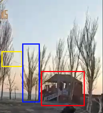
As you may have noticed, there is not much to go by in this footage. However, sometimes that is not a problem at all. In fact, there is enough information on a single frame at 0:06 to be able to geolocate this scenario in just a few minutes.

What can we see in the image that can help us identify the location?
First thing is the obvious building. Doesn’t look like a house. It has some white stairs on the side, it’s fairly small and has a lot of open space. Maybe a place to rent for events, perhaps a cafe, a restaurant?
We can also see trees, plenty of them and an open area leading up to them. These two features will be easily visible in satellite view.
There’s also a cable above, probably leading to an electrical pole.
On top of all of this, I bet that I can spot the sea in the distance and judging by the fact that Mariupol is a coastal city this would be a very good guess.
And do you remember how I said this was probably recorded at sunset due to the colouration of the sky? We can see how the right side of the image is slightly more orangy than the left side of the image. This would indicate that the sun is setting on our right. Knowing that the sun rises on the East and sets on the West, we now know that we are most likely facing South.
Geolocating
Now we can just go to Google Maps and check out what Mariupol looks like as we already know that, based on the caption of the tweet, this happened in that area.

Mariupol is quite a big city but we have enough to narrow down our search by a lot. We can go directly to the coast and we might even start on the right side of the screen as it is the coastal area that faces the South the most.
Within seconds you would spot this area:

What do we see here? Some structure by the beach with a symbol that indicates a cafe, plenty of trees, an area without trees just before the road, and of course the Black Sea.
It looks promising but how do we verify the location?
Verifying
As many other locations in Ukraine, this one has no google street view and only a couple of panoramic images in the distance, both of little help.
But if there is one thing we can always count on is business photos.
So let’s click that yellow symbol above the “Black Corsar” building and see what we can get.

Once you click on it you’ll be shown a bit more information about the business. The photo below is not very useful for us but if you click on it you’ll be able to see the full gallery. Some of the photos would have been posted by the business and some by the patrons.

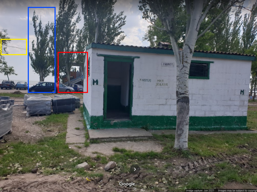
Once you’re in the gallery mode you can keep scrolling down to see more photos. This was the 6th one on the list:

Above we can see the white stairs, the “open area” at the top, and the trees of the same species and height as the ones seen before.
And because I’m never happy with just one point of confirmation, I went back to the map to see if there was anything else I could use.
Not much around apart from that public toilet. But if it’s clickable I’m clicking on it!

Somehow this public bathroom by the sea had 3 photos in its gallery as seen below.

And what can we see just behind it? It’s our cafe, now visible from a similar perspective from the one on the video we are analysing. We can even match the tree and the cable above.
Below on the left you can see the screenshot from the battle in Mariupol, and on the right a photo of the area uploaded to Google Maps public toilet .
Coordinates of where the Chechenian men were seen in active combat in Mariupol, Ukraine on the 19th March 2022:
47.094478, 37.63803.
Conclusion
Sometimes geolocating an image or video is much easier than it looks at first. From footage to geolocation took me around 5 minutes using only Google Maps, one frame of the video, and a lot of analysis.
If I’m honest, the first time I watched the video I had some doubts I would be able to do it (at least in a reasonable amount of time) but sometimes it’s the ones that look the easiest that end up being the hardest ones.
It’s always worth giving it a go.
I hope you enjoyed the walkthrough of my geolocation of the members of the Chechen Sever Battalion in Mariupol.
Thank you for reading!
~Sofia.
